Geographic and Biophysical Description:
18° 4’ 0’’N 66° 2’ 30’’ W
Puerto Rico is approximately 100 miles long by 35 miles wide and is the smallest and the most eastern island of the Greater Antilles (Cuba, Hispaniola, Jamaica and Puerto Rico). It consists of the main island of Puerto Rico and the smaller islands of Vieques, Culebra, Culebrita, Palomino, Mona, and Monito.
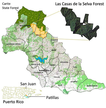
Our forest is located in the Sierra de Cayey in southeastern Puerto Rico, in the Municipality of Patillas, adjacent to the Carite State Forest. It has an area of 957.5 cuerdas (929.9 acres) of land and is an integral part of the watershed of the Río Grande de Patillas. The three districts of Patillas that border the land are Muñoz Rivera, Mulas and Marín.
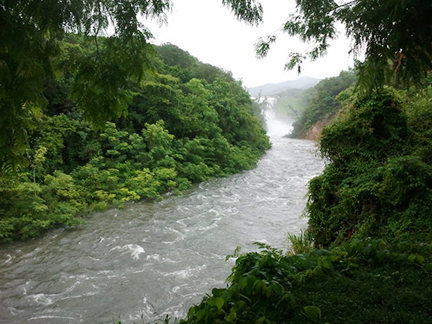
The vast majority of land is steep, with slopes of 40 to 60 degrees. Tributaries and creeks feed the Río Grande de Patillas. It is a spectacular site with steep thickly-forested slopes, and beautiful streams and waterfalls. This area is classified as subtropical wet forest under Holdridge’s Life Zone Systems, and classified as very humid evergreen montano tropical forest by Walsh System. The land elevation fluctuates between 300 and 600 meters (980-1970 ft).
Climate:
The climate of the Río Grande de Patillas is primarily subtropical moist forest and subtropical very moist forest, with frequent heavy rains in the Carite Forest most of the year. Rainfall varies in the basin in a similar pattern to the rest of Puerto Rico, with a relative dry period from January to April, heavy rains in May, a second period of lower rainfall from June to August, and the season of heavy rains until December. The average annual rainfall in the basin is 81 inches (2.05m), ranging from 56 inches on the coast to 105 inches (2.66 m) in the Carite Forest. In years of severe drought, the average annual rainfall inches the basin can be reduced to 57 inches. Evapotranspiration consumes 60% of the rainfall over the basin, about 48 inches per year (43 inches in dry years). The balance between rainfall and evapotranspiration averages 33 inches, which becomes runoff or seeps into the ground. According to Cooperative Weather Station # 66-6904 (Patillas Dam), the annual temperatures average is 78.0°F (25.55°C), while mean annual precipitation ranges from 75 to 85 inches. The newly installed weather station located at Las Casas de la Selva has recorded 102 inches of precipitation during May 2009-May 2010.
Hydrology:
The property is located within Humacao-Río Seco Basin at Río Grande de Patillas watershed, and at least five intermittent tributaries and streams run through or from this property. The Tropic Ventures Project is located in the Río Grande de Patillas watershed in the southeast region of Puerto Rico, in the municipality of Patillas, that has some of its land areas in the municipality of Arroyo. This area is characterized by hills up to 2,988 feet in elevation, with steep slopes and dense forests. The Carite State Forest, which borders the north of the project, was established in 1935 to protect the vital watershed from which the three large rivers, Rio Grande de Loíza, the Rio de la Plata and the Rio Grande de Patillas, are born. The Río Grande de Patillas flows from the Carite State Forest, through our forest, from the Muñoz Rivera ward in Patillas, to the Jagual and Marín wards where the slope decreases and the alluvial valley of the river widens. The Patillas reservoir (Lake Patillas), provides water to the region for home consumption and agricultural irrigation, and is part of the Irrigation District of the South Coast built and operated by the Puerto Rico Electric Power Authority (PREPA). The Río Grande de Patillas and the Río Marín feed the Lake Patillas reservoir 18.5 million cubic meters (15,000 acres-feet). There are shrimp and fish species like guabinas, chopas, dajaos, lobinas, and tilapia in the Lake. The dam was built between 1910 and 1914 by the Puerto Rico Irrigation Service, today known as the Puerto Rico Electric Power Authority.
Soils:
This soil area, described as humid, is classified as an association known as Pandura Rocosa Tierra Patillas. According to the General Soil Map in the “Soil Survey of Humacao Area of Eastern Puerto Rico”, they range from shallow, moderate cliffs to big cliffs with good drainage and elevated plutonic lands.
There are 3 types of associated soils within these lands:
- CbF2- Caguabo arcilloso lómico, from 20 to 60% slope with erosion potential.
- LsF2- Los Guineos limoso arcilloso lómico, from 40 to 60% slope with erosion potential.
- PaF2- Pandura lómico, from 40 to 60% slope with erosion potential.
Earlier Land Use and Recent Activities.
The Patillas Dam. The reservoir is the main supply of water for irrigation, other industries and potable water for 40,000 people in the region.
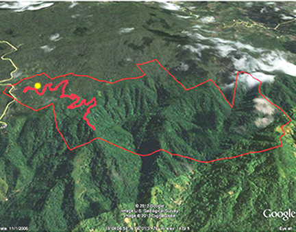
The Bold red line indicates the forest road that runs through plantation land.
The yellow dot indicates the homestead.

- Zone 1: Biodiversity & Water Resources Protection Zone
- Zone 2 and 2a: Forest Plantation Zones
- Zone 3: Homestead & Multiple Use Zone
Map by Mia Sued, Photos by 3t Vakil, & Google Earth
Before Tropic Ventures acquired this land, it was utilized for traditional coffee growing and other minor crops, and forest had been cleared for cattle grazing. In 1983, Tropic Ventures bought these lands and started the experimental enrichment and sustainable forestry project. Since its beginnings, this project has had as its main focus the management and production of valuable hardwood as a source of generating income sustainably. Between 1984 and 1990, line planting of around 40,000 seedlings of a variety of valuable native and introduced broadleaf timber trees, including mahogany (Swietenia macrophylla x S. mahagoni) and mahoe (Talipariti elatum), was carried out on 230 acres (93 hectares) of this land at an average elevation between 350-600 meters.
Lists:
Tree species
Reptiles, Amphibians, Birds, Insects, Fungi, Vines, Ferns, & Lepidoptera.
These lists will be constantly updated as more species are positively identified.
IMPORTANT BACKGROUND:
Most of the original forests of Puerto Rico were logged and converted to agricultural uses over the last several hundred years. A decline in agricultural land use and social and economic changes have permitted these lands to revert to secondary forests. Puerto Rico is one of the few countries in the world reporting large amounts of forest gain, an increase of 211,650 hectares from 1980 to 2003. Currently forests cover 57% of the land surface of Puerto Rico, a sharp increase from a low of around 17% forest cover in 193os (Brandeis et al., 2007).
In Puerto Rico secondary forests are vulnerable because they are perceived as uneconomical, (or worse, as worthless) because regenerating timber species typically take a long time to be harvestable. Research into the ecological management of tropical secondary forest for sustainable timber could contribute to preservation of biodiversity by offering an alternative to clear-cutting or conversion to grazing or agriculture, or other forest damaging development.
One option for forest regeneration and economic enhancement of secondary forests is enrichment planting, where valuable tree species are planted in cleared lines or blocks, simulating forest openings when tall trees fall, within current forest vegetation, offering vital soil protection and facilitating forest development. (Shono et al., 2007). For the last three decades the quest for sustainable forest management continues at Las Casas de la Selva, using forest enrichment as a primary silvicultural technique.